


UPDATED May 5, 2021 at 3:15 P.M. – BRADENTON BEACH – The city’s ongoing efforts to resolve inconsistencies between its future land use and zoning maps could potentially impact property values and the future use of many properties citywide.
The inconsistencies were created when the city adopted a revised future land use map as part of its 2020 comprehensive plan. Building Official Steve Gilbert and City Planner Luis Serna are now guiding the Planning and Zoning Board (P&Z) and the city commission through the early stages of the map revision process. The goal is to make the zoning and future land use maps consistent with each other.
The map revisions being considered are not intended to alter the current use of an impacted property but could become a significant issue if the property is sold, demolished by a storm, or redeveloped in a manner that differs from its current use, possibly impacting the property value.
During the April 21 P&Z meeting, the future land use and zoning maps for the Sandpiper Resort Co-Op were discussed in depth. The future land use and zoning map designations for several properties in the 2200 and 2500 blocks of Gulf Drive North were also discussed in depth.
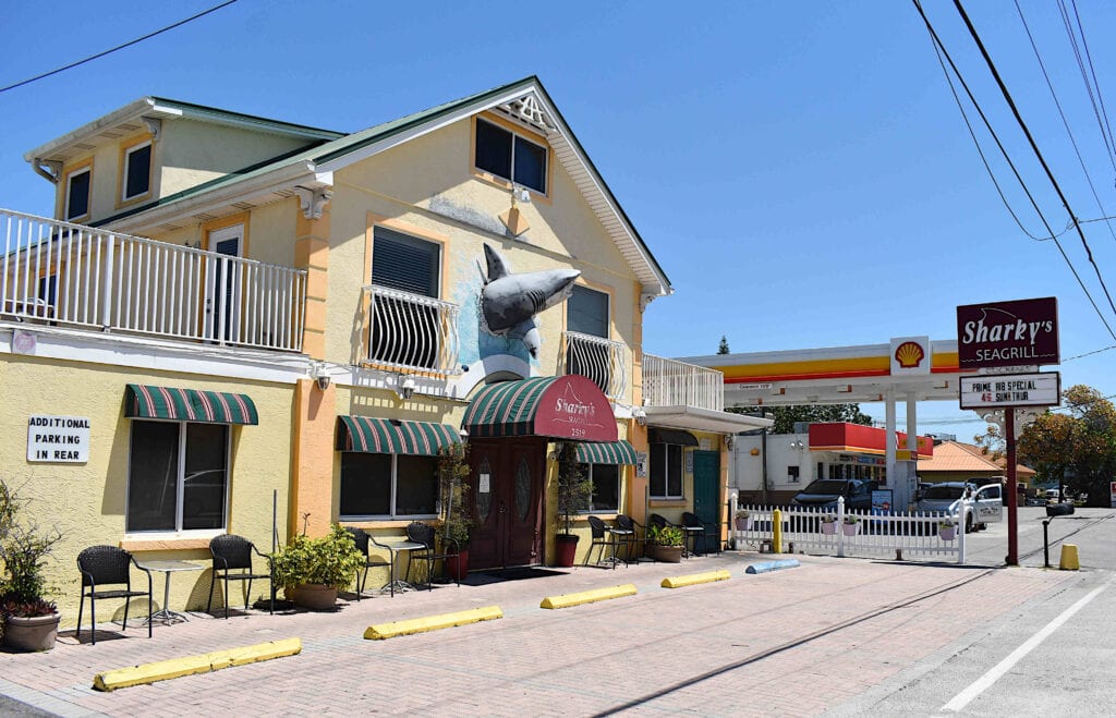
The potentially impacted properties in the 2500 block of Gulf Drive North include Sharky’s Seagrill, the Shell gas pumps and Circle K convenience store, a vacant lot, Club Bamboo and the two-story structure occupied on the ground level by the Studio 104 salon, the KW on the Water real estate office and the Blooms by the Beach florist shop, with residential units located above. Similar map inconsistencies exist in the 2200 block of Gulf Drive that could potentially impact the Aluna Wellness Center & Spa and Wagner Real Estate properties.
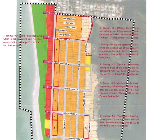
Several other potentially impacted properties throughout the city have not yet been discussed by the P&Z board. The additional maps of these potentially impacted areas and properties can be viewed here. The board’s map revision discussions will continue on Wednesday, May 5 at 11 a.m., with the issue also expected to be discussed at the Wednesday, May 19 P&Z meeting.
During the April 21 meeting, Gilbert said the purpose of that day’s meeting was for the P&Z members to review the proposed map revisions and make their recommendations to the city commission. The city commission has the sole authority to make any final decisions regarding map revisions.
“This is not a public hearing to formally adopt these maps,” Gilbert noted.
Sandpiper Resort
In 2008, the city commission amended the future land use map, decreasing the maximum units allowed on the majority of the Sandpiper property from 18 units per acre to nine. But the coinciding zoning map that establishes the M-1 (mobile home park) zoning district was not revised in 2008 and has not been revised since then. The number of lots allowed by the land development code on the Sandpiper property exceeds the density established by the current future land use map.
According to the future land use map, the majority of the Sandpiper property carries a medium-density residential land use designation. The portion of the property closest to the Anna Maria Sound shoreline carries a low-density residential land use designation.
Gilbert and Serna recommend amending the future land use map designation to high-density residential, which would return the Sandpiper’s future land use designation to its pre-2008 status.
P&Z member John Burns opposed that action and instead proposed revising the zoning map to match the nine units per acre allowed by the future land use map.
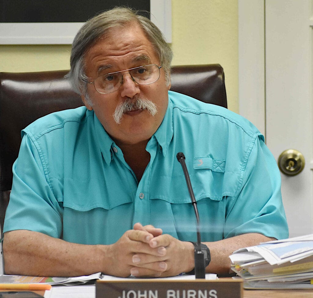
The board members expressed concerns that revising the zoning map to allow 18 units per acre could result in a more intense future use of the Sandpiper Resort property should it ever be redeveloped as something other than a mobile home park. Burns said reversing the 2008 future land use map amendment would double the allowed density.
In response, Serna said, “The intent is to reflect what’s on the ground there currently. This was a change that occurred in 2008, which is basically making those properties non-conforming. They conform to the zoning, but the zoning does not conform to the future land use. We’re really just trying to give them back what they had prior to 2008.”
Burns said he was not aware of any Sandpiper Resort property owners who objected to the 2008 future land use map revision.
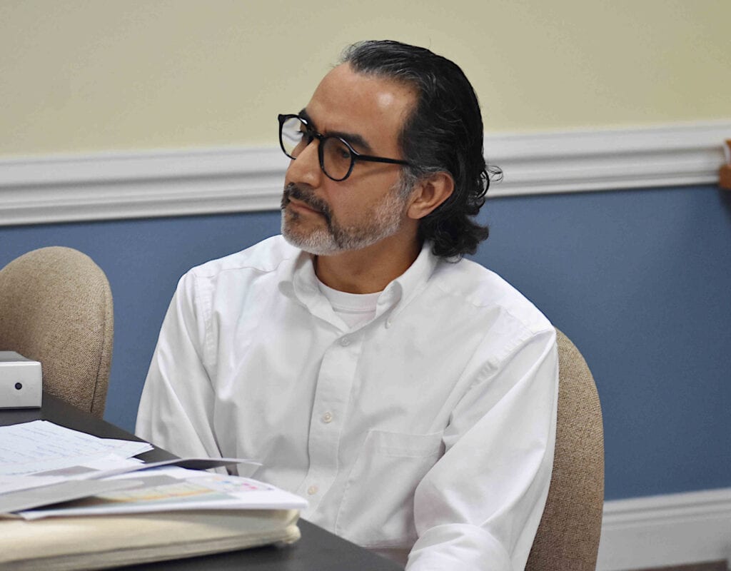
“I’m not sure what the public response was back then, but it is definitely something where the city is out of compliance with its own plan. That’s a concern,” Serna said.
Gilbert said the Sandpiper property has historically been zoned M-1, under the high-density residential criteria, and changing that zoning would have consequences.
“We would be taking away dwelling unit density from them. Which is why we’re recommending making this (the future land use map) consistent with the historic use and the current use rather than rezoning it and potentially causing damage to their property value by changing future land use back to what it was before this map was done,” Gilbert said.
Board member Bill Morrow asked if the Sandpiper Resort community is currently configured to nine units per acre. Gilbert said the current density is much higher than that.
“There are two choices to be made here: one is to revert back to high density for that entire parcel and a future developer could fit quite a few units in there. If you keep it the way it is, future developers are not going to be able to pack as many buildings or dwelling units in there. The second option is to change it (the future land use designation) back so that the mobile home park remains conforming to current zoning, but that also gives them the ability, if they choose to sell the property, to develop the property at 18 units per acre,” Gilbert said.
“I see no benefit to the city nor to adjacent properties in changing it back to the way it was,” Burns said.
The board voted 5-0 in support of Burns’ motion to recommend the city commission amend the zoning map to match the nine units per acre currently allowed by the future land use map, despite the recommendations of Gilbert and Serna.
Gulf Drive North
The board also discussed the map inconsistencies that exist in the 2500 and 2200 blocks of Gulf Drive North.
The future land use map currently designates those areas as R-2 medium density residential with a C-2 general commercial zoning designation.
“All the uses on the property are commercial,” Serna said of the existing property uses.
Serna and Gilbert recommended amending those future land use map designations to Retail/Office/Residential (ROR) in order to be consistent with the existing zoning and current uses of those properties.
Burns expressed concerns that commercially zoned property with an ROR future land use designation would allow new structures to be built with 90% lot coverage.
“You might have 90% lot coverage when you get done with the parking lot, but building coverage, no,” Gilbert responded.
Board member Fred Bartizal said he likes the existing zoning the way it is.
“Why change it?” Burns asked.
“Because the uses of the property are not residential,” Serna replied.
Serna said the Circle K property is zoned C-2 but the future land use designation is medium density residential.
“That’s where the inconsistency is,” he noted.
Burns asked if a new Circle K building could be built on that property if a storm or some other disaster destroyed the existing structure.
In response, Gilbert said, “Not really, because C-2 zoning is not consistent with the medium density dwelling as established by the future land use map. The future land use map says zero to nine dwelling units per acre and no commercial development is to occur there. It’s a residential land use. Your commercial zoning is not consistent with your comprehensive plan and the existing uses there would become non-conforming uses. In order to make them conforming, you either change the future land use map or you change the zoning. To preserve the character of what’s up there now, the future land use map goes to ROR and the zoning goes to mixed-use, rather than commercial.”
“The comp plan is saying that should be residential and what’s on the ground isn’t residential. That’s all we’re trying to fix,” Serna said.
“You’re opening a can of worms to fix it,” Burns replied.
Serna said not allowing commercial structures in those areas could subject the city to legal challenges.
“They could sue the city and that’s the concern we’re trying to address. We don’t want to take away anyone’s rights through down-zoning,” Serna said.
Regarding properties made non-conforming with city code due to past or future commission actions, Serna said, “They can exist as long as they’re not destroyed, but the owners of those properties could rightly come and say we’ve had a development right under zoning and now it’s being taken away.”
Board member Fred Bartizal expressed concerns about making zoning revisions that could potentially allow for more intense development.
“What worries me is there’s some pretty smart developers out there right now with some real smart lawyers. If we change any of them, will it make it easier for them?” he said.
Board chair Ken McDonough noted the challenge for the city is what happens if a property owner wants to develop a property where there are inconsistencies between the zoning and future land use maps.
“What do you do? Do you go by the zone map? Do you go by the future land use map?” he asked.
“That’s why we’re having this discussion,” Gilbert said. “There’s a vacant lot next to the Circle K. It’s zoned C-2. The land use is duplex and they want to put in shopping. If we follow the zoning it will become a duplex.”
The board unanimously supported Burns’ motion to recommend the city commission change the zoning map to match the current future land use map, which is medium density residential, R-2 – which allows single-family residences or multi-family duplexes and apartments, despite what Gilbert and Serna recommended.
Gilbert noted that before any final map revision decisions are made by the city commission, all potentially impacted property owners will be notified and will have the opportunity to address the P&Z board and the city commission when future public hearings are held.
Related coverage