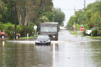
A car and truck inch along North Shore Drive, a lake forms on
Poinsettia Road.
PHOTO PROVIDED BY CATHY STOLTZFUS
One of the most intense series of rainstorms in recent memory flooded many areas on the Anna Maria Island over the weekend, forcing many residents into mop-up mode.
While the official rainfall at the Sarasota-Manatee Airport only showed 3.03 inches of rain on Saturday, which is a new one-day record, areas west got much more water on Friday and Saturday.
“Radar estimates on the Island were closer to nine inches,” said Rick Davis, forecaster for the National Weather Service in Ruskin. “In northwest Bradenton, where I live, my rain gauge measured 8.6 inches.”
Each of the three cities experienced flooding, although it could have been worse.
“We got flooding in spots that normally flood and then some,” said Holmes Beach Police Chief Jay Romine. “City crews got signs out to warn of the deep water as it got worse. I came out Sunday and most of those areas were dry.”
Romine said, however, that it was much worse out east where the rains caused rivers to flood.
Public works crews were out Monday morning cleaning debris from formerly flooded streets and public areas in the city.
Anna Maria Public Works Director George McKay said he measured seven inches of rain at his home rain gauge Friday and Saturday. He was busy Saturday closing residential streets.
“It was basically a lake east of Gulf Drive from Magnolia to Willow,” he said. ‘Other areas were north of Gulf Drive and North Shore, at Cypress and Newton, north of North Bay and North Shore and at South Bay.”
McKay said flood damage to homes in the north end of the city was made worse by sightseers.
“We put up signs and barricades and they moved them and drove through,” he said. “They either don’t know or don’t care about what their wake does to the flooded homes.”
Bradenton Beach Public Works Director Char Patterson said that the two men who worked Saturday collecting trash also cleaned drains in the area of Avenue B between 22nd and 23rd Streets in the north part of the city. She said public works received no reports from homeowners about flooded homes.
Davis said that the rain was not the result of any tropical activity
“It was a very old frontal boundary that was, for the most part, southwest of us,” he said. “It moved north Friday, stalled out over Tampa Bay Saturday and acted as a focusing area for rain. The heaviest part of that rain was southwest of the front, from Egmont Key south to Anna Maria Island.”